
Services


3D scanning 


Le balayage laser est une méthode efficace pour documenter et numériser un bâtiment, une route ou un terrain avec une grande précision. Nous proposons la numérisation laser à partir de nombreuses plateformes différentes et sommes experts dans la recherche de la solution la mieux adaptée aux besoins de nos clients, généralement en combinant différentes méthodes de numérisation. 

3D scanning


Project planning with high precision 

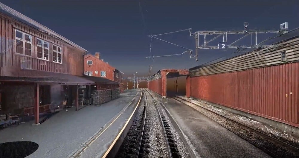
Le balayage laser 3D est l'une des méthodes de balayage les plus précises que nous utilisons.

Le scanner laser est statique et se déplace manuellement d'une position de balayage à l'autre, ce qui permet d'obtenir un nuage de points très détaillé avec des couleurs RVB et des images panoramiques à 360°.

Les nuages de points d'une telle précision et d'un tel niveau de détail sont idéaux pour documenter une situation existante.

Cette méthode peut être utilisée de différentes manières, notamment :   

  • Adocumentation construite par l'entreprise
  • Plans en 2D 
  • Modèles 3D (BIM) avec le niveau de détail souhaité 
  • Visualisation     
  • Analyse 
  • Photos panoramiques à 360 degrés


Numérisation laser 3D


Balayage terrestre

Frequently asked questions:


What is 3D scanning?

3D scanning uses various types of sensors to reliably measure and record objects in three-dimensional space. The resulting point cloud of data provides accurate point clouds of interior environments, buildings, or structures. This is useful in architecture, engineering, and other fields for accurate documentation and analysis of indoor environments.

What accuracy do you need?

The accuracy you order has a lot to do with the price. In general, the higher the accuracy you need, the more it costs. Consider what you will use the result for. And choose the accuracy according to your needs. We are happy to help you make the right choice!

Revit, ArchiCAD, and IFC models?

All three are BIM (Building Information Models). Which one do you need? Check who will be working with the model and what they prefer to work in. An architect will often prefer an ArchiCAD model. Others will prefer a Revit model. And some will only want a 2D drawing. Be sure before you order. You can save a lot of time and money here. We can also help you figure out what you need!

Do you offer Google Street View?

Are you tired of traveling to the project to take measurements and check things that were forgotten during the inspection? We can scan and create a Google Street View of your project so you can take measurements and even operate the building from your PC, mobile phone, or tablet.

What does LOD mean?

In 3D scanning, LOD refers to different levels of detail that can be selected based on the needs and purpose of the model. Lower LODs can be used to represent general shapes and contours, while higher LODs provide more detailed information, including smaller details and textures.

How does 3D scanning improve quality control?

A 3D scan is excellent for checking that what has actually been built is in accordance with the drawings. We use 3D scans and compare them with the BIM model. This allows us to see what is within tolerances and what is outside them.


Modèle de balayage laser 3D du réseau ferroviaire

Prendre contact

La solution à l'amiable

Norvège

Dagfinn Solvik-Olsen

Leder, Field Survey

+47 930 48 141

Sven Bratland

Norvège

Sven Bratland

Regionsleder, Field Survey Bergen

+47 474 07 550

Lasse Turunen

Finlande

Lasse Turunen

Business Manager, Analytics & Software

+35 850 491 5180

Victor Kvarnström

Suède

Victor Kvarnström

Regionsleder, Field Survey Göteborg

+46 (0)70 249 51 74


Arpentage_64x64

Arpentage

L'arpentage joue un rôle essentiel dans la phase de planification et d'exécution de la plupart des projets d'infrastructure et de construction dans le monde. L'arpentage garantit la précision entre les modèles numériques et le monde physique. La technique d'arpentage détermine la position géographique précise en trois dimensions des points, ainsi que les distances et les angles entre eux. Notre équipe a une grande expérience de la prestation de services de topographie pour les gouvernements, les entreprises et les particuliers, principalement en Norvège, mais aussi en Suède et en Finlande. Pour en savoir plus sur les services d'arpentage sur Field , voir ci-dessous.

Solutions géospatiales alimentées par des logiciels, des capteurs et des technologies d'IA.

Rejoignez-nous et aidez-nous à capturer et à transformer des données géospatiales précises en informations précieuses et en jumeaux numériques.